<Background of Activities>
In Laos, with economic development and the increase in automobile traffic, the number of traffic accident casualties is on the rise. It is a reality that many patients who suffer fatal injuries in traffic accidents die on the roadside without being transported to a hospital. Until around 2010, roadside deaths were a “daily occurrence” in Laos.
In the absence of public emergency transportation services, young people who were distressed by the daily roadside deaths began volunteer emergency transportation. The activities of private emergency teams composed of citizen volunteers have become more active in recent years, especially in the capital, Vientiane. As of 2021, five rescue organizations have been approved by the government and are responsible for emergency transportation in Vientiane. They operate on donations, using inadequate equipment, and provide free emergency transportation services 24 hours a day. However, there were accumulated issues that needed to be addressed to make their activities more efficient and advanced, such as the education system for emergency teams and strengthening cooperation with medical institutions.
To reduce traffic accidents, it is important to know the locations and situations in which traffic accidents occur and the types of injuries they cause. However, in Laos, information about traffic accidents (such as location, time, and circumstances) is not recorded, and injury records are kept on paper, with no analysis of accident data.
<Contents of Activity>
To solve these issues, the project aimed to develop and introduce an Emergency Medical Service Support System (ESS) that records the activities of emergency teams and transmits this data from the ambulance to the hospital in advance. It was expected that this data would be used to improve education, road maintenance, and traffic violation enforcement, thereby reducing traffic accidents. In May 2024, a traffic safety seminar was held at Vientiane High School based on the analysis of data accumulated in the ESS.
After the introduction of the ESS, a survey of its usage revealed that most rescue teams had more registered members than the number of dispatches, and there was a high turnover frequency among members. This indicated issues with the communication and sharing of the purpose and procedures for using the ESS within the teams. Additionally, it was found that there is no understanding the use of devices during pre-hospital activities, leading to reluctance in using the ESS. At the enf of the project, JICA and the project implementing organization explained to the Ministry of Health and Mittaphab Hospital that analyzing the data obtained through the continuous use of the ESS could lead to measures to reduce traffic accident fatalities. We recommended training to ensure that rescue teams could continue to use the ESS.

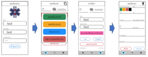
(Photo of ambulance-mounted smartphone operation)
ESS is a web application that can be operated with a smartphone, making it easy for first responders who use smartphones on a daily basis.
<System Description>
By operating along the flow of activities from ambulance dispatch to arrival at the scene, life-saving measures, and arrival at the hospital, the respective times are recorded. The data accumulated in the ESS, such as the accident location, dispatch time, number of transports by hospital and team, types of traffic accidents, and time taken from dispatch to hospital arrival, can be instantly checked using the ESS’s analysis function. It is also possible to record the injured person’s injury sites and photos of the accident scene. By analyzing these, the data can be used to implement measures to reduce traffic accidents.
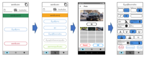
(Screen shot of the ESS smartphone app used by Rescue)
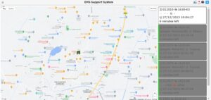
(Example of data analysis screen: accident locations can be shown by period, accident type, etc.)
2. Pre-hospital information is transmitted in advance to medical institutions accepting emergency transport
Data on the sick and injured can be received from the ambulance transporting the sick and injured and transmitted to the hospital. The hospital can then check the information on the number of the sick and injured patients to be transported (number of people and symptoms) and the current location of the ambulance on a display monitor. The information is labeled in order of severity, from red to yellow to green. Hospitals can improve the lifesaving rate by preparing to receive patients according to the severity of its information.
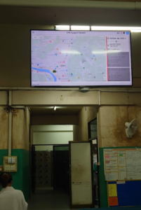
(Left: Display installed in the hospital; Right: Display screen)
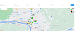
3. Monitoring the location and availability of ambulances in the city, and the availability of the 3 central hospitals
The Command and Control Center (CCC) utilizes the GPS function of smart phones deployed at five rescue organizations (1623, 1624, 1625, 1628, and 1630) in Vientiane City to monitor the location of ambulances. This allows CCC dispatchers to send out dispatch instructions to the vehicle closest to the accident scene based on the location information of the ambulance.
In addition, the CCC can check the availability of ambulance transports (i.e., acceptable or unacceptable) entered into the ESS by the three central hospitals (Mittaphab Hospital, Setthathirath Hospital, and Mahosot Hospital).
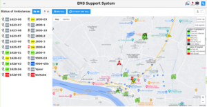
(Screen displayed at CCC)
Next Page: Training for Emergency Care Professionals
The articles, photographs, illustrations, etc. on this website are protected by copyright law.
Therefore, reprinting, copying, reproduction, translation, etc. without permission of the copyright holder is prohibited by law.
If you wish to reprint, etc., please contact us at the e-mail address below.